This section describes determination of aquifer properties based on monitoring of groundwater levels near a river or lake/pond.
Dialog window can be opened by selecting menu "File > Hydrogeologist workbench > Stream-aquifer interactions".
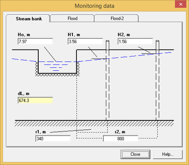
Hydraulic resistance of the river bottom is determined using measurements of water levels in the river and the two observation wells that are located along the line, that is perpendicular to the river. It is recommended that the first well is located at a distance from the river equal to the aquifer thickness. The second well is ideally located at the distance of 50-100 m from the first well.
"Stream bank" tab of "Monitoring data" dialog box.
Explanatory table for the tab "Stream bank"
References Опытно-фильтрационные работы. Под редакцией В.М. Шестакова и Д.Н. Башкатова. М.: Недра, 1974.
|
| 2. Calculations of flood/water rise impact on groundwater levels |
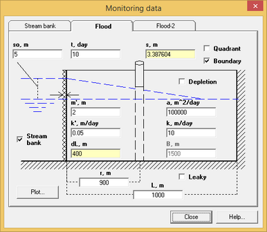
The solution assumes instantaneous water level rise in the river/lake. It can account for hydraulic resistance of the river bed, no-flow boundaries and downward leakage through the aquifer bottom.
"Flood" tab of "Monitoring data" dialog box.
Explanatory table for the tab "Flood"
References Hall F.R., Moench A.F. Application of the convolution equation to stream-aquifer relationship // Water Resources Research. 1972. Vol. 8, N 2. P. 487–493. Teloglou I.S., Bansal R.K. Transient solution for stream-unconfined aquifer interaction due to time varying stream head and in the presence of leakage // Journal of Hydrology. 2012. Vol. 428–429. P. 68–79.
|
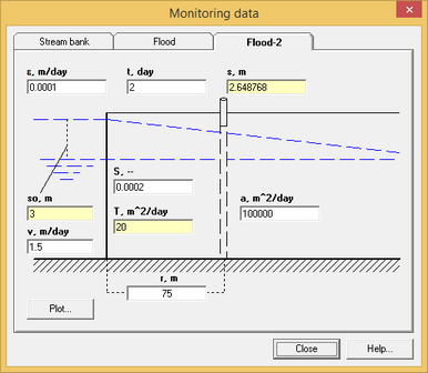
"Flood-2" tab of "Monitoring data" dialog box.
Explanatory table for the tab "Flood-2"
References Основы гидрогеологических расчетов. Ф.М. Бочевер, И.В.Гармонов, А.В.Лебедев, В.М.Шестаков. М., Изд-во «Недра», 1969.
|